Uvinje, Tanzania – an Indigenous community erased in the name of conservation
Uvinje, Tanzania – an indigenous community erased in the name of conservation
Published in The Ecologist
3rd October 2014
Once again, the Government of Tanzania’s conservation agencies are attempting to expel people from their homes and land in the name of conservation. The people of the coastal fishing community of Uvinje inhabit land which the Tanzania National Parks Authority (TANAPA) claims is now part of Saadani National Park, and they are being told to leave. While this may sound all too familiar, the story of Uvinje—a small community of 21 households and a total population of only 130 people—is different in some ways from recent events in Loliondo2.
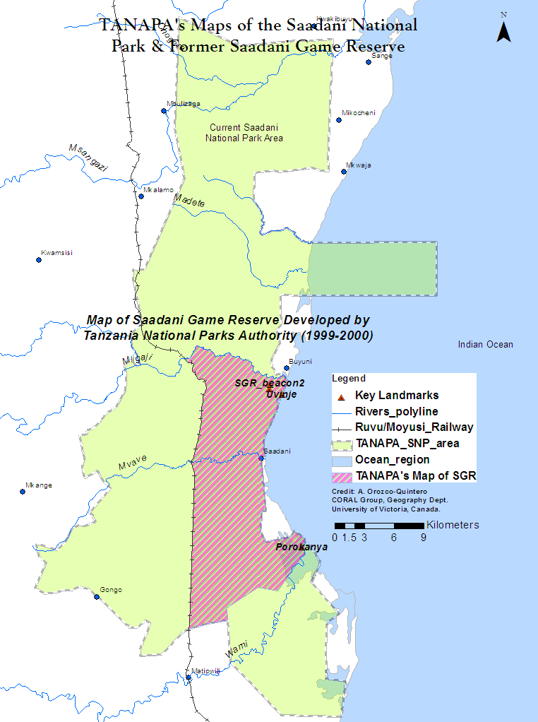
It is different particularly for the way that the planned eviction has come about: not by TANAPA following the procedures that are laid down for it to acquire land from villages for national parks—procedures that are stacked in its favour anyway—but by its taking advantage of poor record keeping to ignore the original boundaries and to create its own new map of the Game Reserve with the boundaries in a different location to ensure that Uvinje’s land would be inside the new national park.
A partnership for conservation betrayed
In the 1960s, Saadani village, including its sub-village Uvinje, invited the Wildlife Division to help them conserve the wildlife being indiscriminately killed in their area by outsiders. A partnership emerged and Saadani Game Reserve was officially gazetted in 1974 with the full support of Saadani village, which willingly gave up more than 50% of its land for the Reserve. In the late 1990s TANAPA came in to “upgrade” the Game Reserve to a national park and a process of consultation ensued.
The National Park was to be larger than the original Reserve, and additional land was added to the north, west and southern sides of the Reserve. However, never in the course of these consultations or in the official documentation on the creation of the Park was there any mention of annexing further land from the eastern side of the Reserve which was comprised of the coastal strip of Saadani village’s remaining territory. On the contrary, District authorities secured a written commitment from TANAPA to return to the village a 1.5 km long area along the Reserve’s eastern boundary adjacent to the narrow strip of land comprising the village centre. Not only was this commitment never honoured, but somehow the original boundaries instead shifted to include the totality of Uvinje and Porokanya, Saadani’s two main coastal sub-villages, as well as part of the Saadani village centre.
District and other authorities gave their approval, unaware that the original boundaries of the Reserve at Saadani village had changed. Once village leaders became aware that TANAPA had redrawn the boundaries, they sent numerous queries and protests to higher authorities, all of which were ignored. Saadani National Park, with TANAPA’s preferred boundaries, was gazetted by Parliament in 2005. Three different independent research reports confirm what elders and elected leaders of Uvinje and Saadani have been claiming all along: that they have never been within the Reserve or the Park. Presumably, under Tanzanian law TANAPA has no authority to evict people from a national park if they are not actually in a national park.
Evictions and the public interest
Another discrepancy between TANAPA’s and the village’s version of events relates to the number of families in Uvinje who have accepted compensation from TANAPA and the number who remain in the village. The Deputy Minister of Natural Resources and Tourism seems to have been told that only four families have refused compensation. According to leaders of Uvinje and documentary evidence, however, TANAPA’s most recent compensation list, one of at least three different compensation lists, is made up of people who do not live there, and omits everyone who does. As shown in an annex to an open letter sent to President Kikwete by the Indigenous Peoples’ and Community Conserved Territories and Areas (ICCA), Uvinje has an adult population of sixty, none of whom seem to have any interest in leaving their homes.
A successful partnership for conservation
Independent research has shown that the original agreement leading to the creation of Saadani Game Reserve resulted in three decades of successful collaboration for conservation. This collaboration resulted in effective partnerships to address poaching, community-based lodging for tourists and increased grassroots awareness and engagement in conservation, as well as enabling a welcoming reception to TANAPA in the initial stages of establishing the park.
The people of Uvinje, despite not having shared in any of the benefits from conservation since the establishment of the Park, have remained stewards of their traditional lands and the wildlife through their collective disapproval of poaching, their autonomous decision to stop saltmining, formerly their main source of income, because of its detrimental impacts on conservation, and their investment in a small eco-lodge. Yet, TANAPA has refused to allow the eco-lodge to move forward, and has instead issued its own call for Expressions of Interest for a luxury tented camp in Uvinje’s territory to cater international tourism. Tanzanian law allows for TANAPA to acquire village land when they can show that it is in the public interest.
This history, however, raises the inevitable question of whether the public interest would be better served by allowing Saadani village to be meaningfully connected to conservation efforts, and residents of its Uvinje sub-village to continue living in their homes and earning their conservation-friendly livelihoods.
The ticking clock
Precisely when it was that senior government officials became aware of the way in which TANAPA has laid claim to Uvinje’s land is not clear. What is clear is that the increasing attention from Tanzanian media3 and efforts from organizations concerned with human rights have triggered a series of denials on the part of various authorities, as they assign blame for instance to “a foreigner who makes the villagers stubborn” despite the fact that the Uvinje’s leaders have been seeking redress since 2001. However, now the shifting of the boundaries is well documented and has become public knowledge.
Organizations such as Minority Rights Group International (MRG), a leading international human rights organization and the Indigenous Peoples’ and Community Conserved Territories and Areas (ICCA) a consortium with members from over 50 countries see this as a question of human rights. How the Government of Tanzania now responds will reveal how President Kikwete sees the situation. The people of Uvinje see it quite simply: it is a trust betrayed, a complete disregard of their roots, identity, and stewardship of nature, and ultimately the loss of their home, the annihilation of their existence.

Map of Saadani National Park and former Saadani Game Reserve created by TANAPA. (Source:Layers from TANAPA’s 2010-2020 Park management plan).

The oldest Saadani Game Reserve map found so far. Uvinje and its territory are mistakenly designated as “Mbuyuni Village land South of Mligaji River” territory—Buyuni village is located north of Mligaji River, and Uvinje to the south. In any case, the map is clear that the Game Reserve (no. 3 on the map) does not include the village land. The map is presumed to be the original SGR map which was presented to Uvinje and Saadani elders involved in the establishment of the reserve. (Source Map: 1996 Report on Research Commissioned by the Wildlife Division to the University of Dar Es Salaam)

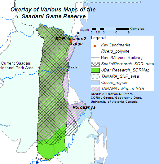
Overlay of various maps of the Saadani Game Reserve. The basic two differences between the SGR maps from the University of Dar es Salaam and the 2013 doctoral research are: (1) the exact location of the reserve’s eastern boundary (while the U. Dar es Salaam research used the road between Mkwaja village and Wami river as the boundary line, the doctoral research set the boundary based on the location of 2 original game reserve beacons (~500m to the West of the road)) and; (2) the southern portion of the reserve (U of Dar took Wami River as the southern boundary, while in the doctoral research the boundary tries to follow the land features included in the original gazette notice of the Reserve). Neither one of the two maps developed through independent research include the coastal sub-village areas of Uvinje and Porokanya as part of the original area comprising the reserve.
Notes
- Alejandra Orozco-Quintero is a PhD student in Geography at the University of Victoria in Canada. Her comparative research on The Role of Knowledge, Institutions and Multi-level Governance in Adaptive Capacity focused on the spatial and institutional dynamics taking place within and around the Pacific Rim National Park Reserve in Canada and the Saadani National Park in Tanzania.Contact: Aleja@uvic.ca
- http://www.tnrf.org/en/loliondo;http://www.maliasili.org/conservation-land-grabbing-and-the-case-of-loliondo/; http://www.iccaconsortium.org/wp-content/uploads/all-africa.pdf; http://www.iccaconsortium.org/wpcontent/ uploads/guardian.com_.pdf
- The Guardian News TZ; The Citizen News; Mwananchi News_TZ ; The Citizen News_TZ